Peekaboo & Spooky Slots: September 27, 2023

This warning wasn’t nearly enough! Amelia post “hike” fitting her body between the posts.

I’m going to do my best with words and photos to take you along the odyssey that was Peekaboo & Spooky. Our friends the Noltes, Bill & Marianne, were in the area so we met for two days of adventures. They had never been in a slot before, so we were super excited to take them out to Peekaboo and Spooky. We’ve been to plenty of slots, narrows, and gulches, but never to these two famous slots.

IMG_5878

The sign as you enter Hole in the Rock Road where were camped a half mile away. The trailhead was 24 miles down the road. It wasn’t a horrible road, just an insane amount of washboard. The kind of road where you are hoping none of the fillings come out of your molars. It also tested the Nolte’s Mercedes Sprinter. They learned a few lessons for sure, like when all of a sudden beer spewed out of a cabinet and dripped everywhere.


img_5879

We started at Upper Dry Fork Trailhead to hike the Dry Fork Narrows to Peekaboo then to Spooky and back on the Rim Trail. You can see from the map Peekaboo and Spooky are directional, for a very good reason.


IMG_5801

Everything was just hunky-dory while we were in the Dry Fork Narrows. The Noltes were super stoked. Mare couldn’t take enough photos. 😊


IMG_5788

Happy smiling people in the Dry Fork Narrows.

IMG_1694

Still smiling and I was even beginning to wonder if we were in Peekaboo.

IMG_1777

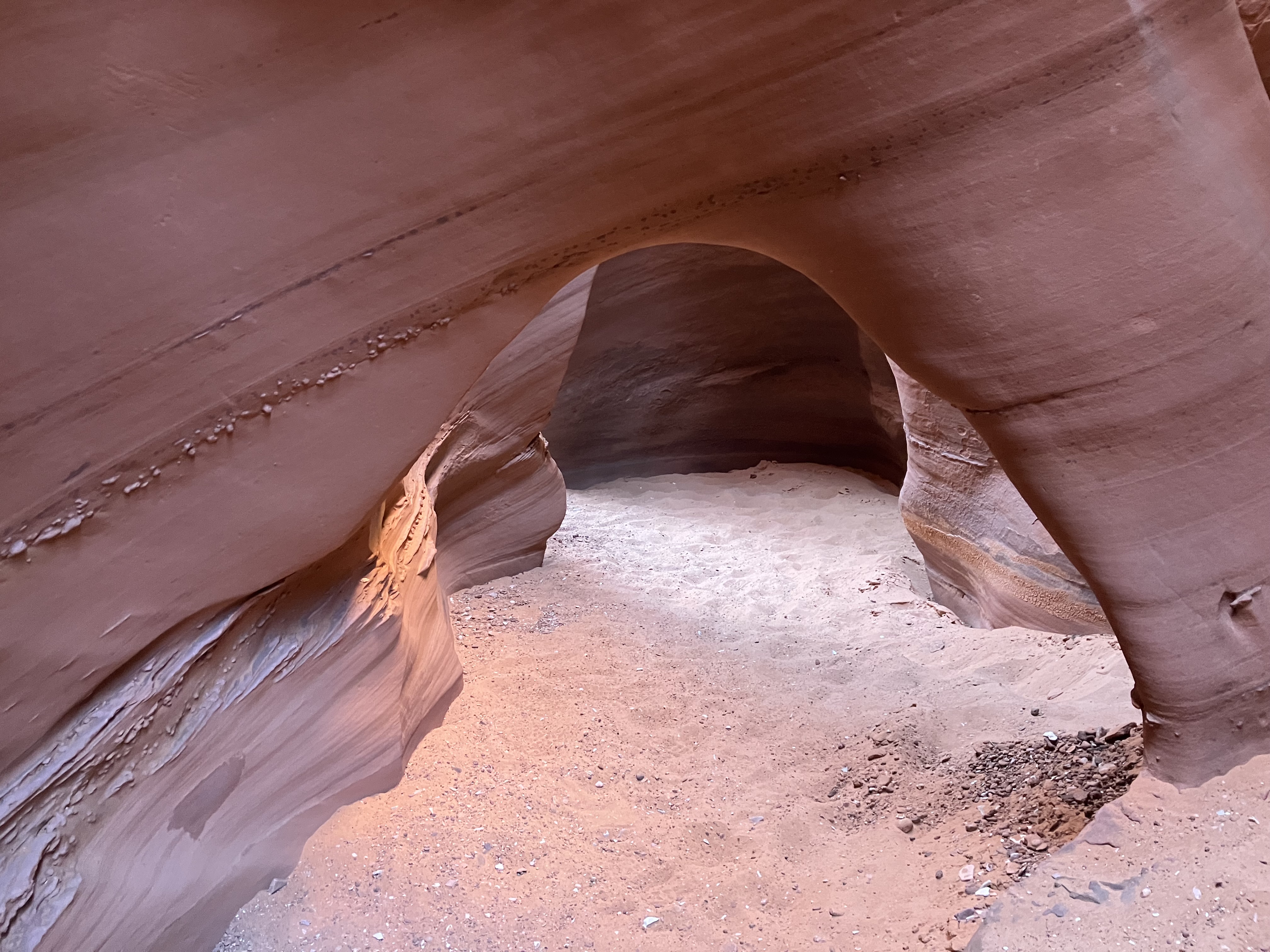
This is the entrance to Peekaboo! Holy shit! Are you kidding me? I know for sure if it were just us, we would’ve turned around, probably the same for the Noltes, but two couples together changed the dynamics.


And so begins Peekaboo.


Peekaboo is an upstream hike. More than once Nolte had to help all of us navigate an up section.


IMG_5805

There’s many Peekaboo slots in Utah, but this is the real one.

IMG_1743

Somewhere in the middle of Peekaboo

img_2187

As we exited Peekaboo we were left with a real sense of accomplishment. It was the right mix of stress, strength, endurance, and exhilaration. 

IMG_5807

Bill straddling the slot that is Peekaboo.

IMG_5784

Once we left Peekaboo we made a cross country trek to Spooky.

IMG_5818

The beginning of Spooky…not looking too spooky yet.

IMG_5821

Starting to get tight.

IMG_5819

And then we came upon a guided group of six. One of the girls was paralyzed with fear as the guide was trying to coax through a maneuver. At this point Mare dropped a “William” on Bill as he crept closer to get a view. The guide was saying things like, this choke point is a lot worse since the flood in June. And this is the point of no return, once you are down this there’s no going back. Standing, waiting, and watching was beginning to let fear enter my mind. Finally they let us pass and gave the poor terrified girl a break. We wonder if they ever made it through or just turned around.

IMG_5820

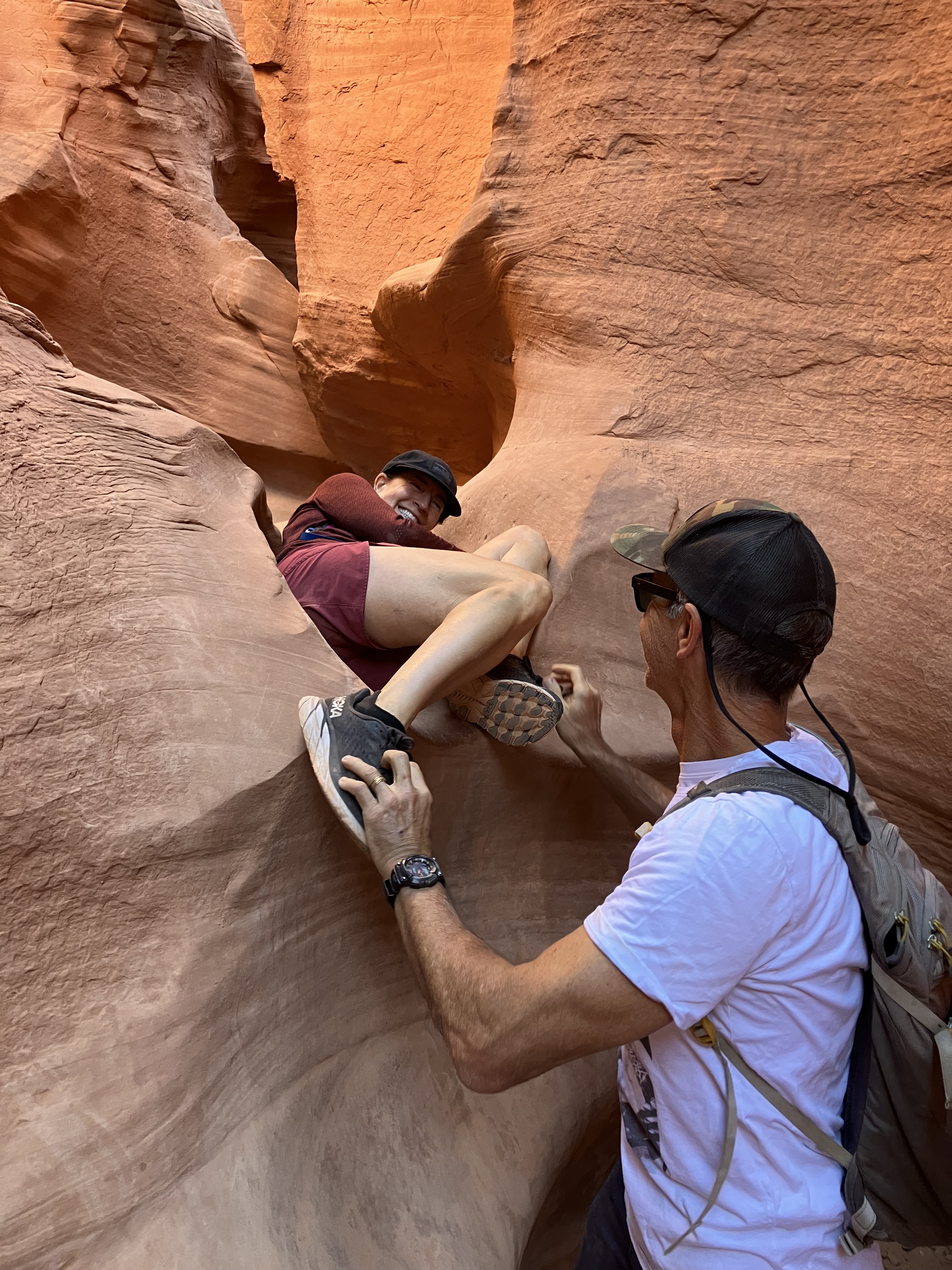
Here’s the choke point. Mare at the top, Bill talking her through the required steps. All of a sudden I was in the lead.

IMG_1765

By the time I entered this spot I had worked myself into a full on panic attack. I was long gone by the time the three of them got here. There was no end in sight to the gnarly ups, downs, twists, and turns. I tried to breath and remain calm, but I couldn’t. I just started moving as fast as I could. I was tearing up my clothes, getting bruised, leaving a trail of blood, scratching my watch, and shredding my iPhone case. I felt horrible leaving everyone behind, especially Amelia. I knew Bill was with them, but still…

IMG_1762

Bill was taking these pics. He had a sense I might’ve fled. Amelia and Mare had a brief moment of panic, being in the comfort of each other more than likely helped them. This is the stretch I remember having no sense of how long it was going to go on. It felt like there was no end.


IMG_1767

Slot? More like a slit in the earth. I get uneasy just looking at this picture.

IMG_1771

Light at the end. So thankful and relieved, but riddled with guilt.


IMG_5826

The view as we marched through the heat back to the trailhead. I did my best to laugh and make light of my panic attack. I’ve never experienced one of that magnitude. It was not fun. Spooky still haunts me. I’ve never left my wife behind like that. I can’t begin to verbalize how awful it feels.

Kodachrome Basin State Park: September 20-24, 2023

IMG_5681

Geoduck Spire

Just in case there’s some youngsters reading this post, Kodachrome was a color film used in cameras and motion pictures, aka movies. The Eastman Kodak Company had Kodachrome on the market for 74 years in various formats, but discontinued it in 2009.

The Kodachrome Basin story goes something like this…way back in 1949 The National Geographic Society and The Explorers of New York organized an expedition to explore one of the least known wild areas in the United States. That last frontier in Utah was known as Escalante Land. The colors were so amazing and constantly changing throughout the day that they coined it Kodachrome Flat.

In 1960, the area was set aside as a State Reserve and the name was officially changed to Kodachrome Basin with Kodak’s blessing.

We were pretty hyped to camp here and we were not let down. It was an amazing area and a terrific campground. It was very quiet. The generator hours are from 12pm-4pm! So that certainly helps with the noise. And for the first time this trip it was really noticeable that we are no longer vacationing on a teacher’s schedule. Typically in a campground like this there would be kids doing laps on bikes and scooters, but there no kids in sight.

The only downside is zero cell service, but the visitor’s center has WiFi and waffle cones and is less than two miles from the campground. If you do happen to find yourself here do not bike Shepard Canyon. It’s complete hell on a bike. 

IMG_5682

Another Utah state park off the checklist.


img_5632

Site 23 at sunrise, there’s that Geoduck Spire again.


IMG_5570

Scooby-Doo and Shaggy were our neighbors. Astro from The Jetsons was also in the campground.


IMG_5581

A view of the aptly named Basin Campground. If you look closely you can see our shiny Airstream and the Geoduck Spire.


img_5622

I find so much humor in this. 😂 I can just visualize some idiot wanting a refund because there were bugs!


img_5607

Kodachrome did have a few nice short biking trails, this is Grand Parade trail.


IMG_5589

From Angel’s Palace Trail looking at the entrance to the state park


img_5659

Golden Crownbeard


img_5661

Crested Wheatgrass


IMG_5666

We left the park twice to do some hikes. This is Willis Creek.


IMG_5640

I really like the pine trees in this photo.


IMG_5665

Close to the confluence of Willis Creek and Sheep Creek.  I’m nowhere near close to being an engineer, heck I don’t even know if engineers make these type of calculations, but that’s Amelia at the bottom of the shear wall. My guess is it’s 250 feet tall.


IMG_2156

The famous Grosvenor Arch. It’s 11 miles from Kodachrome.


IMG_5705

Cottonwood Narrows


IMG_5709

Narrows are not as tight as slots, this is about as tight as Cottonwood got.


IMG_5718

Some scrambling required!


img_5716

Tufted Evening Primrose


img_5670

I just love it when people do things like this to signs.


img_5730

There are 70 spires in the park. This is Chimney Rock.

img_5676

Finally we had some evening color!


img_5678

And a sunset on Geoduck Spire

I just couldn’t help myself 😉

Kanab, Utah: September 11-20, 2023

img_5520

Buckskin Gulch

The hail you say! We originally planned on being in Kanab six days, we stayed nine. Our plans were blown up by the tail end of the monsoon season.  We had some rain five days in a row. The last place you want to be is in a slot canyon during a downpour or stuck boondocking in the middle of nowhere waiting for the dirt roads to dry. I’ve got a couple of videos from the biggest deluge, including hail, but they are so laced with profanities that the editor has advised not including them in the post. I really had no choice but to agree with her, but if you’re dying to see it contact me. 😉

I swear 😂 every time we turned our heads we saw a new RV park or one under construction.  I’m not one to make predictions, but my sense is the demand will be over met and hopefully competition will drive down the nightly rate.

Two weeks into our trip, the hot water heater crapped out on us. We called a mobile RV mechanic. He was a 17-year-old kid that came out once his classes were over at Kanab High School and fixed it. All it needed was a $10 part.

File this under it’s a small world: I visited a chiropractor in town, Dr. Marc Grow, the guy was Class of 2002 from Poway High.

This isn’t a mountain biking town, but if you’re here with your bike go ride Tilted Mesa. It’s a great little trail system and it was never crowded. All the crowds were at the popular hiking trailheads. Still hard to believe it’s mid September and this many folks are out and about. Apparently the cat is out of the bag, but the early bird still gets the worm.

Now without further ado, here are the pictures.

IMG_5055

Here’s the top secret spot we stayed at for 6 days. Prior to this we fell for the hype and stayed at an expensive “boutique” RV park called Dark Sky.

IMG_5107

Peekaboo Slot Canyon: to get there it’s a deep sandy road that I wouldn’t even attempt in our old 4×4 Tundra, so we hired a guide through Dreamland Safari Tours, the same outfit that took us to The Wave.

IMG_5124

Another glowing shot

IMG_5174

The tour also took us to the White Wave. It was cool, but nowhere near the other worldliness of The Wave.

IMG_5179

Here’s a perspective shot of a rock monolith with people in it. 

IMG_5190

On the other side of the rock monolith was this alcove with petroglyphs.

IMG_5191

Cool petroglyphs

IMG_5183

Prairie Spiderwort, funny name for a beautiful flower

img_5557

Tilted Mesa, developed by the Bureau of Land Management. Kudos to them! They did a terrific job.

IMG_2098

63 year old singlespeeder!

IMG_5457

We saw a lot of galls on the oak trees. They are smaller than the ones we see in San Diego. The internets explains it as: “leaves that have developed into a thin sphere because wasps have laid eggs inside of the leaf. Inside the gall is a tiny wasp larva.”

img_5215

Lucky ducks!

The day after The Wave we did Wire Pass slot to some of Buckskin Gulch. It’s our second time in Buckskin. If you are ever out here I would suggest starting from the Buckskin Gulch Trailhead instead of Wire Pass.

IMG_5541

The narrow Wire Pass slot

IMG_5534

All the rain made Buckskin Gulch a slippery muddy mess, so we ended up focusing on our foot steps a lot!

IMG_5521

Close to our turnaround point, further down required wading.

img_5515

There’s no denying it, the glow in a slot canyon is pretty cool.

IMG_5468

Apache Plume

Before leaving Kanab we dipped in to Arizona to get beer since Utah is Utah.

Winner, Winner, Chicken Dinner! September 17, 2023

Written by Amelia Photos & captions by Greg

IMG_5428
The Wave

Coyote Buttes North, aka The Wave, is a once in a lifetime experience that requires a permit…a permit that is obtained by lottery…a three month advance lottery or a two day advance lottery all done via your mobile device. 

Before the internets and mobile devices, permits were granted via lottery in person at the BLM office in Kanab, Utah.  A decade ago Mr. and Mrs. Fancy Pants thought they’d leave Lee’s Ferry campground in AZ at the crack of dawn to get to the BLM office for the lottery.  After about an hour of driving one of us realized Utah was an hour ahead of AZ so that meant we would arrive after the lottery was over. Huge disappointment.

We’d heard of people trying over 30 times and never getting a permit. So we decided to enter the lottery for both Coyote Buttes North and South hoping to get one of the permits.  Both are incredible, but North is more popular because of The Wave, so South is supposedly easier to get. At 7:10PM we started counting down the minutes to 7:15PM when the results would be emailed.

Winner, winner, chicken dinner!  We got both permits!

A phone call was made, a guide was hired, we declined the Coyote Buttes South, accepted the coveted North, and Mr. and Mrs. Fancy Pants could barely sleep! 

Our guide, Andrea, showed us more than The Wave.  She took us to places we would have never found without her!

Oh my God Becky! I smiled ALL DAY LONG!

img_5462-1
😁 So lucky!
img_5227

The arduous off camber trek to The Wave with our trusty guide Andrea leading the way.


img_5247

We walked by many large buttes.


img_5250

Andrea was super stoked about all the reflection pools.


img_5275

Look at that smile! Once again, the early bird gets the worm. We left Kanab at 6AM and had The Wave to ourselves in the morning.


img_5298

Early morning light


img_5398

Miles of this rock


img_5277

I got some great reflection shots. This one might be my favorite.


img_5317

This one’s not bad 😊


img_5304

Nor is this one 😉


Heading above The Wave to see some other worldly stuff.

IMG_5346

Other worldly


IMG_5352

We were just speechless.


img_3691

Amelia on top of a sand dune inside an alcove. 😳


IMG_5375

Another quarter mile of some crazy climbing brought us to Melody Arch with its own awesome window!


IMG_5363

This puts the size of the window into perspective.  I love everything about this picture.


IMG_5377

Amelia on the top of the world


IMG_5382

Heading up to Top Rock Arch


IMG_5389

Top Rock Arch


IMG_5404

Back at the bottom of other worldliness looking up at Top Rock Arch.


img_5411

Back at The Wave the colors are quite different in the middle of the day.


img_5433

One last pic of The Wave


IMG_5451

I just had to include this tough little paintbrush…


IMG_5330

…and this hardy Rock Spiraeas.


IMG_5456

The hike back was toasty, but we had ice cold Tecates with lime and salt waiting for us!

We spent seven hours in the Coyote Buttes North Wilderness.  It was a once in a lifetime experience that blew away our expectations.

Coral Pink Sand Dunes: September 10-11, 2023

IMG_4918

Another Utah state park off the checklist.

What a drastic change in the weather. As we were leaving Hurricane it got windy and dark, then came the rain.  It’s less than an hour drive to Coral Pink, and it rained on and off. This was a one nighter, no need to even unhitch, thankfully, because it’s was raining steadily at the campground. The day before it was 97 degrees in Hurricane. At Coral Pink it was 57 degrees and we had our sweats and bedroom slippers on sitting in the Airstream waiting out the weather.

There was zero cell reception. It’s really amazing how much we depend on and take for granted our smart phones. The joke was get on the weather app and check the radar imaging to see when the storm will pass.

It’s so easy to spot the Euros 😂. They are everywhere, even off the beaten path like Coral Pink. I wonder if it’s the same over in Europe? It must be, right? They are probably sitting in their sidewalk cafes laughing and picking out the American tourists in the crowds.

It was a short stop, so it’s a short post.

IMG_4920

Site 23, water, power, and rain

IMG_4916

You probably have to be a sand geek like us to find this fascinating. We actually have our own little collection of sand from dunes we have visited, in small glass jars on our mantel at home 😊.

IMG_4926

The weather let up enough in the evening for a stroll to the viewing platform. That’s the Vermillion Cliffs in the background. The opposite side of the cliffs viewable from Lee’s Ferry, Arizona are much more dramatic.

IMG_4922

It’s not every day you see a Yellow Indian Paintbrush.

The next morning we had beautiful blue skies and plenty of time for a hike before the 2pm checkout.

IMG_4983

Phlox

IMG_4952

Dry on the east side of the ridge, wet on the west side.

IMG_4960

I can’t keep up with Amelia on sand dunes.

IMG_4991

Ponderosa Pines. All sand dunes are different. Coral Pink had a lot of plant life.

IMG_4935

Pale Evening Primrose

IMG_4974

Welsh’s Milkweed

IMG_4992

Badlands Mule-Ears

IMG_4999

The wind forming a cornice.

IMG_4967

This arch in the dunes may look big, but it was only about six inches.

IMG_4962

❤️

Romance of the Road: September 5, 2023-?

IMG_2062

North bound on Interstate 15, approaching Primm, Nevada

img_4735

We’re not living in 1972 anymore…

img_7127

…nor the Summer of ’78.

It’s September of 2023 and we are embarking upon our first real retirement trip. The romance of the road is still exciting, but not the same as it was in the 70s. Nowadays you are battling crowds and climate change/extreme weather. You need back up plans to your back up plans. For instance, originally we were going to boondock at the Hurricane Cliffs Recreation Area. Instead, because of temps in the 90s we are at good ol’ WillowWind RV Park in Hurricane, Utah cranking the AC. We had visions of being footloose and fancy free. We thought our only reservations the entire trip would be at the very popular Kodachrome State Park. I mean it’s post Labor Day, what the heck? A week before leaving, we thought just for fun, we would check availability at our first few stops. That was a wake up call. We grabbed what we could, then looked at Goblin Valley State Park, for October, only to find it completely booked.

When are we going back home to San Diego? Don’t know! Can’t say! Thankfully we have wonderful house sitters manning the fort while we are gone.

IMG_4787

Speaking of extreme weather, yes that was water in the first pic. Here’s an up close view of the remnants of Hilary outside of Primm.

img_4894

If you follow the blog you’ve already seen tons of pics of us riding the rock in the surrounding area of Hurricane. So just one pic this time of the incredible Gooseberry Mesa.

IMG_4833

What a pleasant surprise! There were flowers everywhere, especially these sunflowers. Apparently the heavy rainfall the last few weeks spurred on the bloom.

IMG_4810

Rocky Mountain Bee Plant

IMG_4813

Yellow Bee Plant

IMG_4816

A beautiful field of Hoary Tansy Asters and Lacy Tansy Asters

IMG_4862

Yellow Columbine

IMG_4839

Scarlet Gilia

The Highlight of this stop was the Taylor Creek Hike in the Kolob Canyons area of Zion National Park. To sum it up in a word: WOW!

IMG_2070

The early bird gets the worm!

IMG_4847

Looks like Zion rock to me.

IMG_4856

The kids are calling this forest bathing. We call it an absolutely delightful uncrowded experience in the great outdoors.

IMG_4857

Lucky us! We saw a Utah Milk Snake.

IMG_4877

You should really put Taylor Creek hike on your list.

IMG_4869

Spectacular

IMG_4860

The bottom of the Double Arch Alcove

IMG_4859

Top of the Double Arch Alcove

End of the trail video  😳 Wow! 😍